
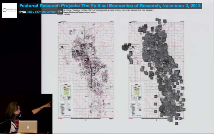
The Emily Carr University of Art and Design has archived the ‘Remaking Research’ symposium online. Here is the link to video documentation of presentations made in ‘Featured Research Projects’ under the theme ‘The Political Economies of Research’ on Friday, November 2, 2012. My presentation is third. Continue reading
Author Archives: Rachele Riley
Proofing my map.
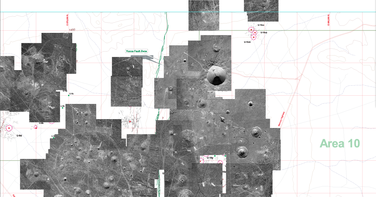
It’s especially moments like these when I wish I could afford to hire a studio assistant. After hours of mapping Yucca Flat last fall, I realized in proofing details in my code, that some of the coordinates for the map are wrong, and that the web is not translating parts of it correctly. It’s difficult to pinpoint where the mistakes are (with so many images tiled upon another), so I have no other option but to go through each detonation again. I will copy the ‘x’ and ‘y’ coordinates again for each: from my master map in Illustrator into my database in Excel (the file that drives the web map). This is a time-consuming task and, as a result, my other studio plans come to a halt. The map is one of the dominant visual features to the archive and it must be accurate. Starting today, let’s see how long this takes me.
My map in Illustrator (Area 2 and 10 in view):
 Continue reading
Update on the ‘Annie’ test mannequins.
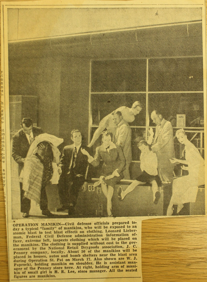
In Las Vegas I found photos of the mannequins being dressed and on display at the J.C. Penney store before the March 17, 1953 detonation.
Las Vegas Review Journal, March 6, 1953.
 Continue reading
The subject of my archival research, appreciating Las Vegas.
There are three main threads to my archival research. I am searching for:
(1) any images or textual accounts of the L.A. Darling Co. Mannequins, information on their public display at the downtown J.C. Penney store in Las Vegas and the tour they allegedly made of other cities, confirmation that they were displayed both before and after the March 17, 1953 ‘Annie’ Test, and any leads to their current whereabouts; Continue reading
Identifying desert flora at the Springs Preserve.
Bladder Sage (Salazaria mexicana)

We made several visits to the Springs Preserve and Nevada State Museum, which are situated in the same area, on beautiful and fittingly-named Valley View Boulevard. Food at the Springs Café is prepared by the Culinary Academy of Las Vegas and we regularly ate there before conducting research at the Cahlan Research Library (within the Nevada State Museum). I would have loved to have had more time for hiking in the Springs Preserve. The short walk we made provided a useful introduction to some plants and has helped me identify some desert flora. I plan to incorporate more of this kind of information into my project, as well as research that I have found on the effects of nuclear testing on the environment. Continue reading
Tour of the Nevada Test Site.
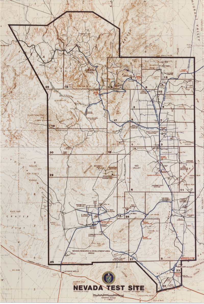
With about twenty-five other visitors, I rode out to the Nevada Test Site on Thursday, December 13. (The Nevada Test Site now goes by the name: Nevada National Security Site.) Our full-day tour was led by Ernie Williams, a former Atomic Energy Commission employee and, at the age of 82, a participant and witness to most U.S. nuclear testing activity.
No pictures, no recording, no cellphones, no video allowed. While we drove around I noted the cable lines strewn about, the few subsidence craters I could see out the window, towers and other testing equipment that stands in ruin, the houses from the 1950s that, situated furthest from ground zero, remain as empty shells, and other evidence of experiments conducted. Continue reading
Nearby, at the Desert National Wildlife Refuge.
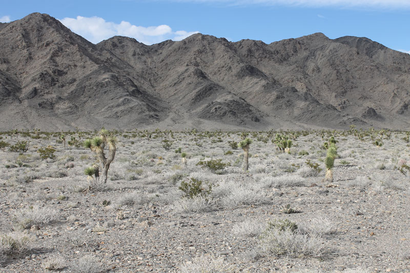
Wednesday, December 12 we drove out to the Desert National Wildlife Refuge on a windy sunny day. We returned dusty, a little sunburned, inspired. The Refuge is about 20 minutes north of Las Vegas, off Highway 95. It is a protected area of 2,300 square miles (from the brochure): ‘The wide range of elevation and rainfall has created amazingly diverse habitat suited to a wide variety of flora and fauna. The Desert Wildlife Refuge is a land of great diversity. Here the Mojave Desert ecosystem merges with the Great Basin ecosystem on this vast dry landscape.’ It is a similar environment to the Nevada Test Site, which lies just beyond, a few ranges away looking north. Continue reading
Artifacts of Atomic Testing.
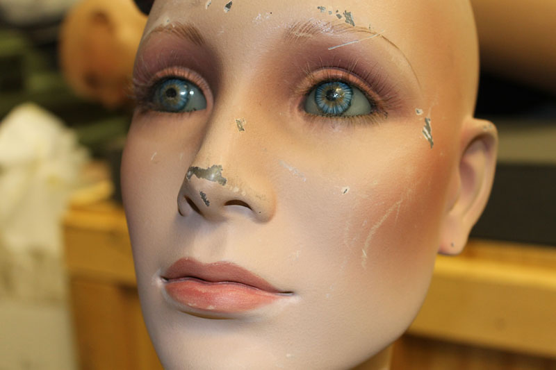
On Tuesday, December 11, I met with Jennifer Cornthwaite, Director of Emergency Arts, at Fremont and sixth to discuss exhibiting in LV, and to get insight into the arts center. I met with Karen Green afterwards at the National Atomic Testing Museum. She is Curator and Collections Director at the Museum. The National Atomic Testing Museum has a collection of artifacts from the atomic testing period, mostly from the Nevada Test Site, but growing in scope to include objects and artifacts from all of the U.S.’s testing locations. I was able to visit the exhibition quickly, and then we went upstairs to the collections room. Karen had received an anonymous donation of two 1950s era mannequins that were used in testing at the NTS, a woman and a boy. The words ‘Property of the Atomic Energy Commission Yucca Flat Range Ground Zero’ are stenciled in black on their backs. Their hair wigs are lost, but their eyes are intact. They have hand-painted glass eyes. Continue reading
In the meadows.
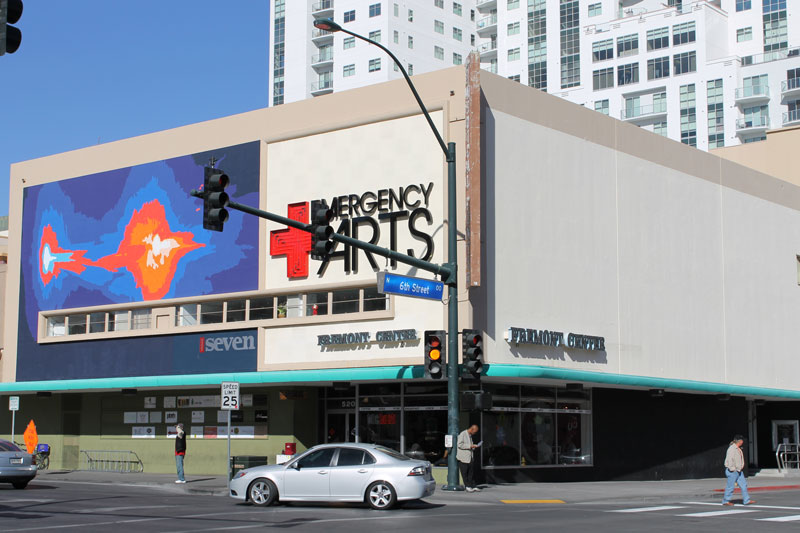
I am in Las Vegas, Nevada for ten days (I arrived Sunday, December 9, 2012). On the first morning, Monday, December 10, I met with curator and historian, Brian Paco Alvarez, and filmmaker and producer, Dan Garrison, at The Beat café in the Emergency Arts Center in downtown Las Vegas (Fremont and 6th). It is in the former J.C. Penney building, the store which donated clothing for Federal Civil Defense Administration tests at the Nevada Test Site in the early 1950s, and the site where the L.A. Darling mannequins, who experienced the force of nuclear blasts, were put on display for public viewing.
Emergency Arts, the former J.C. Penney building:
Expressive scans of drawings.

Here is a selection of recent experiments and interpretations of the cables that lie around the NTS. I have several drawings that have already been incorporated into the web-based archive and I am trying to find other ways to evoke landscape and the ruins of nuclear testing through line and space. The little handheld scanner I use allows me to ‘draw’ as I capture; recorded is the new ‘drawing’ which re-interprets fragments of the original drawing. Each scanning event involves gesture and movement, and the unknown. It is always a surprise to see how the original drawing is transformed. Continue reading
Aerial photographs acquired from the USGS, the Freedom of Information Act.
In June 2011, I discovered that the United States Geological Survey (USGS) Mercury Core Library and Data Center in Henderson, NV stores ‘pre’ and ‘post’ detonation photographs of many nuclear tests conducted at the Nevada Test Site. I immediately inquired if I could have access to the photos of Yucca Flat for my project. After encountering resistance to my inquiry, I filed a Freedom of Information Act Request with the National Nuclear Security Administration (in March 2012), and I am happy to say that it is finally successful. I received all the images in the mail recently: several dozens of black-and-white aerial shots that were scanned and burned to nine discs for me. I want to thank all the people at the USGS and at the NNSA Office of Public Affairs who worked to fulfill my request.
Here are a few examples: Continue reading
Research at the National Archives, ‘Pathway to Peace’ exhibit and presentation.
Looking through the declassified military files entitled ‘General Records Relating to Disarmament, compiled 1948–1962,’ I came upon two interesting exhibition projects. There were two folders dedicated to the ‘Pathway for Peace’ exhibit, which, from what I could tell, was a presentation to the United Nations (given by the U.S.). Continue reading
Research at the National Archives, nuclear detonations and craters.

These images represent just a fraction of the photographs housed at the Archives. Documentation of nuclear testing activity is stored in multiple collections. I poured through the Records of the Department of Energy, the Records of the Defense Nuclear Agency, and the Records of the Defense Civil Preparedness Agency. I will be returning to also consult the Records of the Atomic Energy Commission and to scan a few hundred images for use in my project. I’d like to thank researcher, Kevin Morrow, who generously made a few scans for me one day. Continue reading
Research at the National Archives, Mannequins and real people.
The more I search for details on the mannequins the more the realities begin to blur. Coordinated operations, in which mannequins were carefully dressed and typical social and domestic scenes were staged, began as isolated test scenarios at the Nevada Test Site in 1953. Extending beyond the boundaries of the NTS across the nation, their story culminates in Operation Alert, in which responses to nuclear attack were simulated by real individuals. Here are few images of mannequins and real people:
(Images courtesy of the U.S. National Archives and Records Administration)
 Continue reading
Research at the National Archives, Annie Test Mannequins.
I have been doing research at the National Archives facility in College Park, MD for the last three days. I looked at hundreds of archival documents: photographs, moving pictures, slides, and textual records that relate to nuclear testing at the Nevada Test Site, the Department of Energy, and the Federal Civil Defense Administration. In particular I am searching for any image of the L.A. Darling Co. Mannequins used in the early tests of the 1950’s and documentation of the activities that were carried out in preparation for measuring and assessing the effects of nuclear weapons. I have yet to find evidence of the nationwide tour that the mannequins are supposed to have taken after withstanding the nuclear blast of March 17, 1953.
I requested over 35 boxes of archival records at the Archives and was able to capture reference shots of the material. I will be returning to the Archives to scan the most important findings. Special thanks to my research assistant, Millie Riley.
Here are few images of mannequins used in the 1953 Annie Test that were new to me:
(Images courtesy of the U.S. National Archives and Records Administration)
Before the test, the mannequins are gathered for a photo shoot:

Project featured at ‘Remaking Research’ Symposium.
I just returned from presenting my work and research on ‘The Evolution of Silence’ at ‘Remaking Research: Emerging Research Practices in Art and Design.’ The AICAD symposium, hosted by the Emily Carr University of Art and Design in Vancouver, Canada, was held from November 1–3, 2012. You can view the full lineup of presenters and the symposium schedule here.
I was invited to present under the theme ‘The Political Economies of Research’ in the ‘Featured Research Projects’ section. Continue reading
Awarded an Imagery Grant from the GeoEye Foundation.
I am very pleased to announce that the GeoEye Foundation has approved my grant application. In August I submitted a proposal and request for several high resolution images of Yucca Flat for use in my project, not just for the archive online but for the ways I plan to extend the project as an exhibition.
In an earlier post I described how difficult it was to narrow down my list of requested images to a recommended 5–7 images. The Foundation has generously awarded me six of those seven. Here are the images they gave me, roughly tiled together to show Yucca Flat valley. I can now make use of higher quality imagery (better than my web capture views) that provide much more detail of the landscape.
(Images courtesy of the GeoEye Foundation.)
 Continue reading
A mapping of all underground detonations in Yucca Flat.
I finally finished mapping the sites of underground nuclear tests (still to map are the areas in which atmospheric testing took place). All underground nuclear explosions that took place in Yucca Flat are represented in this map. Individual images for each explosion at the exact site of their detonation are tiled together in (what became for me) a giant jigsaw puzzle, to form one aerial view of the valley.

Mapping Yucca Flat, the remaining Areas.
I have Areas 9, 10, 1, and 8 to complete. I finished plotting the detonations that occurred in Areas 4, 7, 2, and 3. Here are two views of the map in progress. Continue reading
Mapping every detonation in Yucca Flat.
This week I focused on my map. I am tiling the individual images of each detonation to form one view of Yucca Flat valley. Using the USGS map as a guide in identifying the craters, I determine the relative (x,y) positions for each image. I enter that information into my dataset. The web-based archive is designed to pull dynamically from that data file. The map will build itself as it loads online and allow the viewer to interact with each detonation separately.
